Projects
Robinson Creek High Grade Gold
Robinson Creek High Grade Gold
- Drill ready project
- 5 claims, 2 mining leases covering 2.93 square kilometers.
- Compilation of 70 historic drill holes from 1940’ and 1980’s
- 60 of 70 drill holes have gold intersections greater than 1g/t gold.
- Multiple long ore-grade intersections
- 2.46 g/t Au over 57.60 m in DDH 81-2,
- 7.59 g/t Au over 10.94 m in DDH HB-6,
- 3.80 g/t Au over 21.00 m in DDH R07-1
- 2.15 g/t Au over 32.00 m in DDH 81-1
- The drill intersections and the magnetic survey outline a mineralized zone with a strike length of approximately 1,000 metres.
- “At Searchlight we are assessing the Robinson Creek property from a different perspective than past explorers. We see the potential of combining this shallow relatively high-grade gold deposit into a larger consolidated gold project with our brownfield Bootleg Lake Gold holdings nearby’.
Location
- 15 km northwest of Searchlight’s Bootleg Lake claims.
- 17 km west of Creighton, Saskatchewan, and Flin Flon Manitoba
History
70 historic diamond drill holes from the 1940’s and 1980’s by Hudbay and Saskatchewan Mining Development Company SMDC. (Map 1). No work from late 1980’s until present work by Searchlight.
Geology
The Robinson Creek Gold target comprises three gold zones - the Vein, Bleiler, and Quartz Zones - over a strike length of approximately 1 km along the Mosher Lake Shear Zone. The Robinson Creek target is a structurally controlled mesothermal lode gold system, with considerable historical exploration which includes geologic mapping, trenching, soil surveys, airborne and ground geophysical surveys, and 70 diamond drill holes.
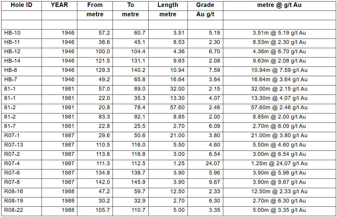
Historical Drilling
- 60 of 70 drill holes have gold intersections greater than 1g/t gold.
- 45 intersections of greater than 2.0 g/t gold over at least one metre
- Multiple long ore-grade intersections
- 2.46 g/t Au over 57.60 m in DDH 81-2,
- 7.59 g/t Au over 10.94 m in DDH HB-6,
- 3.80 g/t Au over 21.00 m in DDH R07-1
- 2.15 g/t Au over 32.00 m in DDH 81-1
Searchlight has completed the compilation of the historical drilling at Robinson Creek, digitizing the detailed drill logs of 70 historic diamond drill holes from the 1940’s and 1980’s. (Map 1) (Map2) These historic drill holes outline a zone of gold mineralization extending at least 1,000 m along the Mosher Lake Shear Zone. Map 2. Significant intersections are listed in Table 1 below.
Table 1: Robinson Creek Gold - Significant drill intersections
Searchlight Resources Exploration
The Robinson Creek project was optioned in July 2021, and in September 2021 Searchlight completed an Airborne Magnetic Survey covering the entire claim block at 50 m line spacing.
Concurrent with the airborne survey an initial site visit to the project was carried out in September 2021 confirming the presence of gold mineralization with multiple grab samples over 10 g/t gold including samples of 19.31 g/t Au and 17.17 g/t Au.
Map 1: Robinson Creek Gold Project – Historic drill holes with gold grade over Magnetic Survey
Map 2: Robinson Creek Gold Project – Significant gold intersections over Magnetic Survey
Disclaimer: Management cautions that the presented drill sample results are historical in nature, and Searchlight has not undertaken any independent investigation of the sampling, nor has it independently analyzed the results of the previous exploration work to verify the results. Searchlight considers these sample results relevant, as the Company uses historical reports and sample results to evaluate and plan future exploration programs. All drill intercepts are drill-indicated lengths. Insufficient technical information exists to demonstrate the true widths of these intersections. The technical information is derived from public documents available through the Saskatchewan Government Ministry of Energy and Resources.