Related Document
0.52% Cu over 190 Ft., 1.06% Cu over 90 Ft. and 1.08% Cu over 50Ft.
Las Vegas, Nevada, December 19, 2006, Canyon Copper Corp. (the 'Company' or 'Canyon Copper') (OTCBB: CYOO) is pleased to announce final results for the remaining eight drill holes from the 33 hole program completed earlier this year on the Company's New York Canyon copper project located in the Santa Fe Mining District, Mineral County, Nevada. All of the recent holes confirm that copper oxide mineralization extends throughout the Longshot Ridge deposit, with four of the holes intersecting significant intervals of copper greater than 1%. These intervals include: hole 06-28R 0.53% Cu over 185 ft with 50 feet averaging 1.08% Cu, hole 06-31R 0.87% Cu over 190 ft with 1.06% Cu over 90 ft, hole 06-32C 0.66% over 83 ft with 1.09% over 38 ft and hole 06-33C 0.52% Cu over 190 ft. All of these recent holes lie within the overall zone of mineralization referred to as the Longshot Ridge deposit.
Final results have been received from the re-analyses of pulps generated from the 2006 drill program. The eight holes available for release include 06-26C, 27R, 28R, 29C, 30R, 31R, 32C and 33C. Reverse Circulation holes are designated "R" and diamond drill core holes are designated "C".
|
Hole ID |
From(ft) |
To(ft) |
Length(ft) |
Copper(%) |
|
06-26C |
20 |
115 |
95 |
0.29 |
|
06-27R |
0 |
70 |
70 |
0.16 |
|
including |
55 |
70 |
15 |
0.37 |
|
|
290 |
330 |
40 |
0.23 |
|
06-28R |
0 |
185 |
185 |
0.53 |
|
including |
35 |
85 |
50 |
1.08 |
|
06-29C |
10 |
45 |
35 |
0.28 |
|
06-30R |
0 |
50 |
50 |
0.23 |
|
|
120 |
225 |
105 |
0.28 |
|
including |
120 |
170 |
50 |
0.45 |
|
06-31R |
0 |
130 |
130 |
0.32 |
|
|
190 |
380 |
190 |
0.87 |
|
including |
285 |
375 |
90 |
1.06 |
|
|
|
|
|
|
|
06-32C |
65 |
148 |
83 |
0.66 |
|
including |
110 |
148 |
38 |
1.09 |
|
|
|
|
|
|
|
06-33C |
10 |
200 |
190 |
0.52 |
|
including |
60 |
95 |
35 |
0.84 |
|
and |
175 |
195 |
20 |
1.50 |
The analyses of total copper content reported here were completed by ALS Chemex using their AA62 atomic absorption procedure. A thorough quality assurance/quality control protocol of certified standard reference materials, duplicates and blanks was conducted during the analytical process.
Drill hole 06-26C is located in the north east portion of Longshot Ridge and was drilled vertically to a depth of 534 feet. Drilling intersected weak skarn alteration in siltstone and limestone of the Gabbs Formation overlying Luning Formation limestone. The hole intersected weak to moderate copper mineralization from the start of sampling at 20 feet to 115 feet and averaged 0.29% Cu over this 95 foot distance. Copper mineralization in nearby outcrop indicates that the mineralization extends from surface.
06-27R is located in the central west edge of the tested limit of Longshot Ridge and was drilled vertically to a depth of 335 feet. Mineralization is hosted within variable skarn alteration in siltstone and limestone. Sampling returned a 15 foot interval from 55 to 70 feet that averaged 0.37% Cu and a 40 foot interval further down the hole from 290 to 330 feet that averaged 0.23% Cu.
06-28R is located 300 feet northwest of 06-27R within a zone of strong skarn alteration of siltstone and limestone within the Gabbs Fm. The hole was drilled vertically to a depth of 345 feet and is the most westerly located hole drilled to date on Longshot Ridge. Surface workings indicate that mineralization extends at least 300 feet further west. Hole 06-28R returned a broad zone of copper mineralization extending from surface to 185 feet that averaged 0.53% Cu and included a strong zone of mineralization extending from 35 feet to 85 feet that averaged 1.08% Cu.
06-29C is located in the northern end of Longshot Ridge and was drilled vertically to a depth of 500 feet. The hole intersected the Luning Formation limestone unit that was non to weakly altered. An interval from the start of sampling at 10 feet to 45 feet averaged 0.28% Cu.
06-30R is located 260 feet southwest of 06-29C and was drilled vertically to a depth of 225 feet. Copper mineralization is hosted within calc-silicate and skarn altered limestone adjacent to quartz monzonite sills. An interval from surface to 50 feet averaged 0.23% Cu and a second interval from 120 to 225 feet averaged 0.28% Cu. The mineralization remains open to the north, west and at depth.
06-31R is located in the west central area of Longshot Ridge. The hole was angled to the northwest at a dip of 600 to a depth of 545 feet. The hole intersected moderate skarn alteration within siltstone and limestone of the Gabbs Fm. Mineralization extends from surface to 380 feet with an upper 130 foot zone averaging 0.32% Cu and a lower 190 foot zone starting at 190 feet that averages 0.87% Cu. Included within this interval is a 90 foot zone extending from 285 feet that averages 1.06% Cu.
06-32C is located at the northern portion of Longshot Ridge. The hole was drilled northwest across stratigraphy at an angle of 700 to a depth of 284 feet. The hole intersected variable calc-silicate and skarn alteration within Gabbs Fm. Sediments. An 83 foot interval starting at 65 feet returned an average of 0.66% Cu. Mineralization appears open to the north but may be limited by a quartz monzonite porphyry intrusion.
06-33C is located in north central Longshot Ridge, approximately 350 feet south of 06-32C. The hole was drilled towards the northwest at an angle of 700 to a depth of 345 feet. Mineralization is hosted within moderate calc-silicate and skarn alteration of the Gabbs Fm. Sediments. A 190 foot zone from the start of sampling at 10 feet to 200 feet averaged 0.52% Cu, with a 20 foot zone from 175 to 195 feet averaging 1.50% Cu.
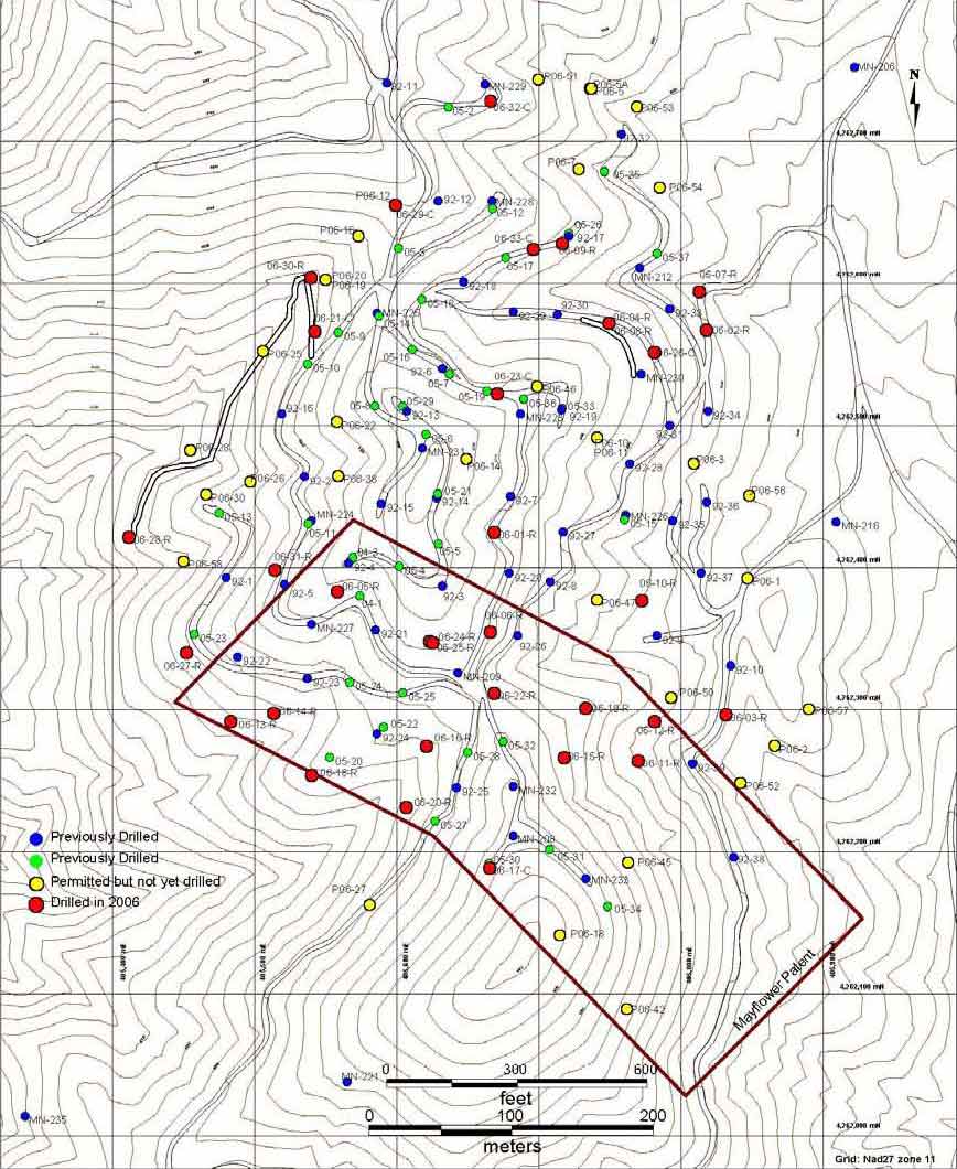
Drilling to date at the Longshot Ridge copper deposit has confirmed and expanded on the known extent of the copper oxide mineralization, which is exposed at surface and has been tested to depths up to 400 feet. With the exception of holes 06-13R and 06-14R reported in the December 5, 2006 news release, all drill holes completed in 2006 have indicated the consistent and wide spread nature of the copper mineralization at Longshot Ridge. The recent data is being incorporated into the overall New York Canyon project database in order to develop a resource estimate of the copper content at Longshot Ridge. A plan outlining the location of drill holes at Longshot Ridge is available for viewing on the Company's website at www.canyoncc.com.
About Canyon Copper
Canyon Copper Corp.'s New York Canyon Property is located in the New York Canyon area of the Santa Fe Mining District, Mineral County, Nevada. The project hosts oxide and sulphide copper bearing mineralization outlined by historical operators. The most advanced of these zones is the Longshot Ridge copper oxide deposit. This zone has not been completely outlined and remains open in several dimensions. The Copper Queen mineralized zone is located approximately three kilometers west of Longshot Ridge and hosts copper and molybdenum sulphide mineralization. Several additional mineralized areas identified throughout the New York Canyon property have yet to be explored.
On behalf of the Board of Directors,
Canyon Copper Corp.
Bryan Wilson, President
For more information contact:
Investor Relations
1-888-331-9326
Disclaimer: This Press Release may contain, in addition to historical information, forward-looking statements within the meaning of Section 27A of the Securities Act of 1933, as amended, and Section 21E of the Securities Exchange Act of 1934, as amended. These forward-looking statements are identified by their use of terms and phrases such as "believe," "expect," "plan," "anticipate" and similar expressions identifying forward-looking statements. Investors should not rely on forward-looking statements because they are subject to a variety of risks, uncertainties and other factors that could cause actual results to differ materially from the Company's expectations, and expressly does not undertake any duty to update forward-looking statements. These factors include, but are not limited to the following, the Company's ability to obtain additional financing, geological or mechanical difficulties affecting the Company's planned geological work programs, uncertainty of estimates of mineralized material and other factors which may cause the actual results, performance or achievements of the Company to be materially different from any future results, performance or achievements expressed or implied by such forward- looking statements.
Drill Plan: Longshot Ridge