
Initial Exploration Target Ranges from 2 – 3 million tonnes with grades between 1.20 g/t -1.60 g/t gold. Amenable to open-pit mining.
“Robinson Creek was last explored during a period when high-grade narrow intersections were the focus of exploration. The Searchlight approach is to explore for both high-grade underground and lower grade open pit targets on every gold project”, stated Stephen Wallace, CEO. “Our initial review of data shows a 55 m section of 2.50 g/t gold in drill hole 81-1, previously presented as short high-grade intersections.”

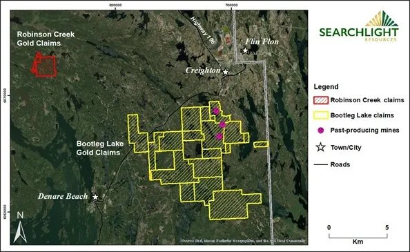
17 km west of Creighton Saskatchewan and Flin Flon Manitoba

Compilation of 70 historic drill holes from 1940’ and 1980’s

60 of 70 drill holes have gold intersections greater than 1g/t gold.

2 – 3 million tonnes with grades between 1.20 g/t – 1.60 g/t gold
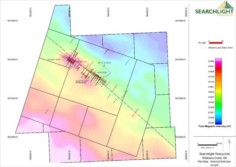
Searchlight has completed the compilation of the historical drilling at Robinson Creek, digitizing the detailed drill logs of 70 historic diamond drill holes totaling 9,618 metres from the 1940’s and 1980’s. (Map 1) (Map 2) These historic drill holes outline a zone of gold mineralization extending at least 1,000 m along the Mosher Lake Shear Zone. Map 2. Significant intersections are listed in Table 1 below.
Geology
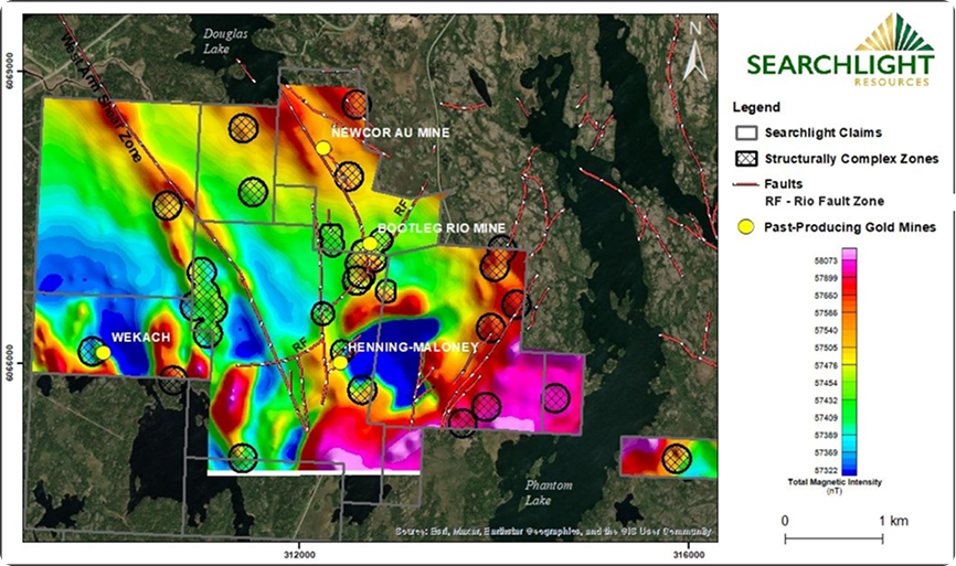
The Robinson Creek Gold Project consists of 2 claim covering 2.93 square kilometres located approximately 15 kilometres northwest of Searchlight’s Bootleg Lake claims (Map 1). The claims have had considerable historical exploration including geologic mapping, trenching, soil surveys, airborne and ground geophysical surveys, and over 75 diamond drill holes.
70 historic diamond drill holes from the 1940’s and 1980’s by Hudbay and Saskatchewan Mining Development Company SMDC. (Map 1). No work from late 1980’s until present work by Searchlight.
15 km northwest of Searchlight’s Bootleg Lake claims.
17 km west of Creighton, Saskatchewan, and Flin Flon Manitoba
60 of 70 drill holes have gold intersections greater than 1 g/t gold
45 intersections of greater than 2.0 g/t gold over at least one metre
2.46 g/t Au over 57.60 m in DDH 81-2,
7.59 g/t Au over 10.94 m in DDH HB-6,
3.80 g/t Au over 21.00 m in DDH R07-1
2.15 g/t Au over 32.00 m in DDH 81-1
The Robinson Creek Gold Project consists of 2 claim covering 2.93 square kilometres located approximately 15 kilometres northwest of Searchlight’s Bootleg Lake claims (Map 1). The claims have had considerable historical exploration including geologic mapping, trenching, soil surveys, airborne and ground geophysical surveys, and over 75 diamond drill holes.
Exploration in the area began in 1915. In 1946, Hudson Bay Exploration carried out initial drilling of 15 holes in the Vein and Quartz zones. From 1970 to 1978, additional trenching in the Quartz Zone was completed, with trench samples returning gold assays ranging from 0.01 to 1.5 oz/ton.
In the 1980s, Suneva and the Saskatchewan Mineral Development Corporation (“SMDC”) joint venture completed over 60 drill holes, with exploration ending in 1989 during a period of low gold prices.
Selected highlights of the drilling are presented in Table 1. Mineralization is open to depth, and there is limited drill testing on multiple additional gold showings. No drilling or surface exploration has been recorded on the claims since 1990.
Geology
The Robinson Creek projects is located with the Flin Flon Snow Lake greenstone belt which hosts significant Gold and VMS mines.
The geological target is a structurally controlled mesothermal lode gold system, with considerable historical exploration which includes geologic mapping, trenching, soil surveys, airborne and ground geophysical surveys, and 70 diamond drill holes
The project comprises three gold zones – the Vein, Bleiler, and Quartz Zones – over a strike length of approximately 1 km along the Mosher Lake Shear Zone.
Drill Hole Compilation 2021
In 2021 Searchlight completed the compilation of the historical drilling at Robinson Creek, digitizing the detailed drill logs of 70 diamond drill holes from the 1940s and 1980s (Map 1).
The results show multiple gold intersections throughout 60 drill holes, with 45 gold intersections greater than 2 g/t over at least one metre. These historic drill holes outline a zone of gold mineralization extending at least 1,000 m along the Mosher Lake Shear Zone (Map 2). Significant intersections are listed in Table 1.
Disclaimer: Management cautions that the presented drill sample results are historical in nature, and Searchlight has not undertaken any independent investigation of the sampling, nor has it independently analyzed the results of the previous exploration work to verify the results. Searchlight considers these sample results relevant, as the Company uses historical reports and sample results to evaluate and plan future exploration programs. All drill intercepts are drill-indicated lengths. Insufficient technical information exists to demonstrate the true widths of these intersections. The technical information is derived from public documents available through the Saskatchewan Government Ministry of Energy and Resources.
| Hole ID | YEAR | From | To | Length | Grade | metre @ g/t Au |
|---|---|---|---|---|---|---|
| metre | metre | metre | Au g/t | |||
| HB-10 | 1946 | 57.2 | 60.7 | 3.51 | 5.19 | 3.51m @ 5.19 g/t Au |
| HB-11 | 1946 | 36.6 | 45.1 | 8.53 | 2.3 | 8.53m @ 2.30 g/t Au |
| HB-12 | 1946 | 100 | 104.4 | 4.36 | 6.7 | 4.36m @ 6.70 g/t Au |
| HB-14 | 1946 | 121.5 | 131.1 | 9.63 | 2.08 | 9.63m @ 2.08 g/t Au |
| HB-6 | 1946 | 129.3 | 140.2 | 10.94 | 7.59 | 10.94m @ 7.59 g/t Au |
| HB-7 | 1946 | 49.2 | 65.8 | 16.64 | 3.64 | 16.64m @ 3.64 g/t Au |
| 81-1 | 1981 | 57 | 89 | 32 | 2.15 | 32.00m @ 2.15 g/t Au |
| 81-1 | 1981 | 22 | 35.3 | 13.3 | 4.07 | 13.30m @ 4.07 g/t Au |
| 81-2 | 1981 | 20.8 | 78.4 | 57.6 | 2.46 | 57.60m @ 2.46 g/t Au |
| 81-2 | 1981 | 83.3 | 92.1 | 8.85 | 2 | 8.85m @ 2.00 g/t Au |
| 81-7 | 1981 | 22.8 | 25.5 | 2.7 | 6.09 | 2.70m @ 6.09 g/t Au |
| R07-1 | 1987 | 29.6 | 50.6 | 21 | 3.8 | 21.00m @ 3.80 g/t Au |
| R07-13 | 1987 | 110.5 | 116 | 5.5 | 4.6 | 5.50m @ 4.60 g/t Au |
| R07-2 | 1987 | 113.8 | 116.8 | 3 | 6.54 | 3.00m @ 6.54 g/t Au |
| R07-4 | 1987 | 111.3 | 112.5 | 1.25 | 24.07 | 1.25m @ 24.07 g/t Au |
| R07-6 | 1987 | 134.8 | 138.7 | 3.9 | 5.96 | 3.90m @ 5.96 g/t Au |
| R07-8 | 1987 | 142 | 145.9 | 3.9 | 9.67 | 3.90m @ 9.67 g/t Au |
| R08-16 | 1988 | 47.2 | 59.7 | 12.5 | 2.33 | 12.50m @ 2.33 g/t Au |
| R08-19 | 1988 | 30.2 | 32.9 | 2.7 | 6.3 | 2.70m @ 6.30 g/t Au |
| R08-22 | 1988 | 105.7 | 110.7 | 5 | 3.35 | 5.00m @ 3.35 g/t Au |
Table 1: Robinson Creek Gold – Significant drill intersections
Searchlight Resources Exploration – 2021
Location of 2021 Grab Samples (need different map)
Robinson Creek Initial Exploration Target
In 2024 Searchlight engaged Terra Modelling Services Inc. of Saskatoon, Saskatchewan, to review the compilation of 70 historic drill holes, create a 3D model of the data, and calculate a set of Exploration Target quantities.
An Initial Exploration Target (“IET”) of between 2 million and 3 million tonnes, with gold grades between 1.20 g/t and 1.60 g/t, was calculated. This equates to an exploration target between 77,000 ounces and 154,000 ounces which is amenable to open-pit mining. Searchlight is currently planning further work to upgrade the IET to a Mineral Resource.
The IET clearly highlights the three know gold zones at Robinson Creek and significantly aid the company in future exploration.

Definition
An initial exploration target in mining refers to an early-stage estimate of potential tonnage and grade derived from preliminary geological data and sampling. It highlights an area’s potential before full mineral resource classification.
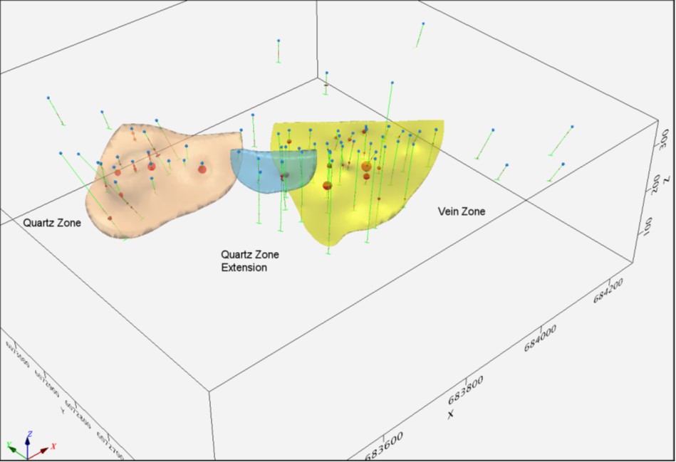
3-d plot of modeled deposits based on historical drilling. View looking NE.
Prepared by Fred Brown, M.Sc. (Eng), P.Geo., RM-SME
Disclaimer: The potential quantity and grades are conceptual in nature. There has been insufficient exploration drilling to define a mineral resource and it is uncertain if further exploration will result in the Exploration Target being delineated as a mineral resource.
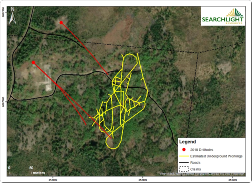
UAV Lidar Survey (need new map)
In July 2026 Searchlight completed a UAV Lidar survey covering the entire Robinson claim block
The map show the Lidar covering the areas of the know drilling and mineralization.
The Lidar clearly shows that surface ridges are associated with the known gold zones.
The image shows areas of future exploration related to ridges.
Location
15km
northwest of Searchlight’s Bootleg Lake claims.
17km
west of Creighton, Saskatchewan, and Flin Flon Manitoba
9km
for Highway 106
Flin Flon is a major mining centre with required logistics and work fore for exploration and development.
Claims
2 claims covering 2.93 Sq km
Acquisition
Initially optioned in 2021 with a 100% ownership completed in 2025