
Mari Lake Gold Project Summary
High Grade Gold Target in Saskatchewan.
Multiple samples over 1.0 oz/ton and with multiple reports of Visible Gold
Last reported exploration in 1986, excellent target for modern exploration
Highlights
22 drillholes, 45 trenches and pits with multiple reports of Visible Gold.
Gold mineralized structure over 700 metres in length.
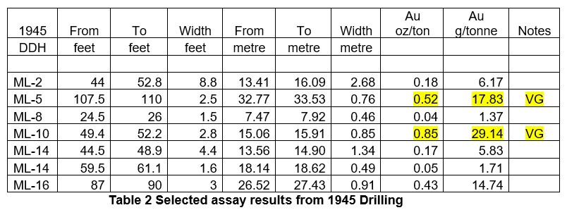
Drill hole samples of 0.85 oz/ton Au over 2.8 feet and 0.52 oz/ton Au over 2.5 feet, with visible gold.
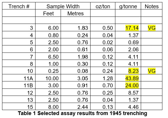
Trench samples of 1.28 oz/ton Au over 10 feet and 0.50 oz/ton Au over 6.0 feet, with visible gold.
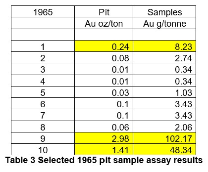
Pit samples of 2.98 oz/ton Au and 1.41 oz/ton Au.
Grab samples of 2.48 oz/ton Au and 1.1 oz/ton Au, with visible gold.
Location
Approximately 30km north of Creighton, Saskatchewan and Flin Flon, Manitoba
Located approximately 40 km north of Searchlight Resources Bootleg Lake and Robinson Creek gold projects. (Map 1)
Located 1.2 km north of the northeast end of Mari Lake
A 1.2 km road connects the exploration area to Mari Lake.
Geology and Mineralization
The Mari Lake Project is situated at the geological contact between the Kipahigan granodiorite and the Kisseynew gneisses in the Kisseynew Domain. The mineralized zone, which strikes northwest and dips 45°NE consists of a series of white, glassy massive gold bearing quartz veins with associated blebs and disseminations of pyrite, pyrrhotite, chalcopyrite, possible molybdenite and tourmaline
Significant gold concentrations are associated with wide zones of shearing and silicification along the granodiorite margin. Gold mineralization is linked to subtle secondary fracturing and microstructures that crosscut the main structural trend. Folding and boudinage of the quartz veins suggest that the quartz veins were intruded into the shear system as fracture fillings early in the history of the shear zones.
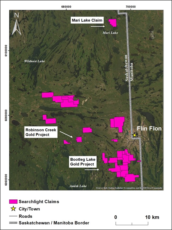
Map 1: Mari Lake Location Map
Exploration
Gold was discovered in the Eccles (Mari) Lake area in the 1930s, with significant exploration between 1945 and 1986. There is no record of exploration after 1986, leaving the project open for modern exploration by Searchlight.
1945
In 1945, Nesnah Mining and Exploration Company Limited completed 15 trenches and 16 diamond drill holes [1, 2]. The trenching exposed gold mineralization over a strike length of 1,075 ft (327.7 m). The most significant results were in Trench 11 with assays of 1.28 oz/ton (43.89 g/t) Au over 10 ft (3.05 m), and 0.70 oz/ton (24.0 g/t) Au over 3.0 feet (0.91m).
Visible gold was reported in trenches 3 and 10. (Table 1)
The 16 shallow drill holes totaled 1,709 feet (520.8 m). Visible gold was reported in two drill intersections, with corresponding assays of 0.85 oz/ton (29.14 g/t) Au over 2.8 ft (0.85 m), and 0.52 oz/ton (17.83 g/t) Au over 2.5 ft (0.76 m) (Table 1). Drill Hole ML 14 shows two zones of gold mineralization. (Table 2)
1954 Referance
- Saskatchewan Mineral Deposit Index – 0411. Eccles Lake Au-Cu-Mo Showing or Dolly Au-Cu-Mo Showing
- Saskatchewan Mineral Assessment Database File 63N04-0002
1965
In 1965, a total of 10 pits were completed, with results which included 2.98 oz/ton Au, and 1.41 oz/ton Au [3]. A quartz vein 7.8 ft by 440 ft (2.37 m by 134.2 m) was exposed as part of a stripped outcrop measuring 980 ft by164 ft (298.7 m by 49.98 m). (Table3)
Searchlight Resources Expands the Mari Lake High-Grade Gold Project
Expands Mari Lake claims from 4.8 sq km to 43.1 sq km
Expands exposure from 3.1 km to 7.0 km along the Kississing River Shear Zone
All claims acquired by staking, 100% held, no royalties
Exploration plans to fly high-resolution magnetic survey
Searchlight has staked an additional 38.3 sq km of claims on the Mari Lake high-grade gold project located approximately 30 km north of Creighton, Saskatchewan and Flin Flon, Manitoba, and 40 km north of the Company’s Bootleg Lake Gold Project (Map 1).
Recent claim staking has increased the Mari Lake project to 43.1 sq km from the original 4.8 sq km, with all claims acquired through cost-effective staking. Searchlight holds a 100% interest in these claims, with no royalties.
The new claims also increase Searchlight’s exposure along the Kississing River Shear Zone which hosts the known high-grade gold occurrences, from 3.1 km to 7.0 km (Map 2). The Company is planning a high-resolution airborne magnetic survey to highlight the Kississing River Shear Zone and other geological structures related to the high-grade gold mineralization.
“With these new claims, Searchlight consolidates its exploration position in the Mari Lake area, allowing the Company to now begin exploration with a geological site visit and airborne magnetic survey.
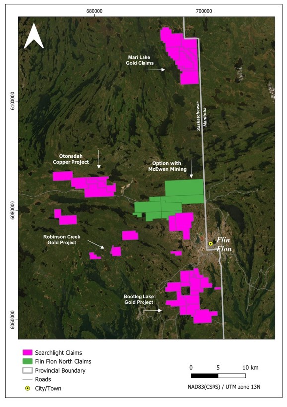
Map 1. Location of Mari Lake and other Searchlight Resources projects.
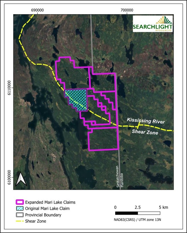
Map 2. Mari Lake Gold Claims located on the Kississing River Shear Zone.
Searchlight Begins Airborne Surveys on the Mari Lake Gold Project in Saskatchewan
Searchlight begins
high-resolution airborne magnetic and radiometric surveys covering all Mari Lake claims, are underway. The claims are located approximately 30 km north of Creighton, Saskatchewan and Flin Flon, Manitoba, and 40 km north of the Company’s Bootleg Lake Gold Project (Map 1).
Searchlight has contracted Special Projects of Calgary to carry out the airborne magnetic and radiometric surveys on the Mari Lake Gold Project. The Company has recently expanded the Mari Lake claims to 43.1 sq km from the original 4.8 sq km (Map 2). The surveys will cover the entire claim block, focusing on the Kississing River Shear Zone which hosts the known high-grade gold occurrences.
“Despite the encouraging results from prior surface sampling and diamond drilling, Mari Lake is still relatively unexplored, as drilling was done to a vertical depth of less than 50 meters, and no geophysics was done to find additional gold bearing structures. Searchlight’s current exploration program will address some of these limitations” stated Stephen Wallace, Searchlight’s CEO.
Searchlight has contracted TUZO GeoSurveys to carry out the UAV photogrammetry and Lidar survey at Robinson Creek, in preparation for the planned diamond drilling program to verify historical results.